Tour Zu Fuß Bay of Islands-Whangaroa Community - Te Araroa - alternative route - Photo

Tous les sentiers balisés d’Europe GUIDE+

© OpenStreetMap contributors
Länge
Länge
11,3 km
Maximale Höhe
Maximale Höhe
9 m
Positive Höhendifferenz
8 m
Km-Effort
Km-Effort  
11,4 km
Min. Höhe
Min. Höhe
-1 m
Negative Höhendifferenz
5 m
Boucle
Boucle
Nein
Kennzeichnung
Kennzeichnung
Erstellungsdatum :
2025-02-07 18:38:22.877
Letzte Änderung :
2025-02-07 18:38:22.877

(0 Nachricht)

Zu Fuß
Zu Fuß
2h34
Schwierigkeit : Einfach

Scannen Sie diesen QR-Code, um die Tour in der SityTrail-Anwendung zu öffnen

Kostenlosegpshiking-Anwendung

Logo SityTrail SityTrail

IGN / Geografische Institute

SityTrail aus dem App Store herunterladen SityTrail von Google Play herunterladen

Logo SityTrail SityTrail World

Die Welt öffnet sich für Sie

SityTrail aus dem App Store herunterladen SityTrail von Google Play herunterladen SityTrail auf Huawei AppGallery herunterladen

Über SityTrail

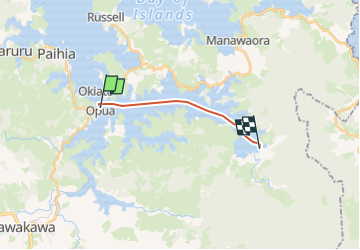
Tour Zu Fuß von 11,3 km verfügbar auf Northland, Far North District, Bay of Islands-Whangaroa Community. Diese Tour wird von SityTrail - itinéraires balisés pédestres vorgeschlagen.

Höhenprofil

Foto-Galerie

Ort

Land:
New Zealand
Region :
Northland
Abteilung/Provinz :
Far North District
Kommune :
Bay of Islands-Whangaroa Community
Standort:
Unknown
Gehen Sie:(UTM)
238183 ; 6088523 (60H) S.

Touren in der Umgebung

Tour Zu Fuß Bay of Islands-Whangaroa Community - Te Araroa - 01 Northland - f Opua to Waikare - Photo
Zu Fuß
GUIDE+

Zu Fuß

Medium
Bay of Islands-Whangaroa Community, Northland, Far North District, New Zealand
19,6 km | 25 km-effort
5h 46min
Nein
Tour Zu Fuß Bay of Islands-Whangaroa Community - Te Araroa - 01 Northland - e Waitangi Bridge to Opua - Photo
Zu Fuß
GUIDE+

Zu Fuß

Einfach
Bay of Islands-Whangaroa Community, Northland, Far North District, New Zealand
8,6 km | 11,1 km-effort
2h 31min
Nein


Schließen
Meine Abonnements